Salkantay trek to Machu Picchu: 5-day itinerary
Cusco: 5-Day Salkantay Ultimate Trek to Machu Picchu
Why serious trekkers often prefer Salkantay
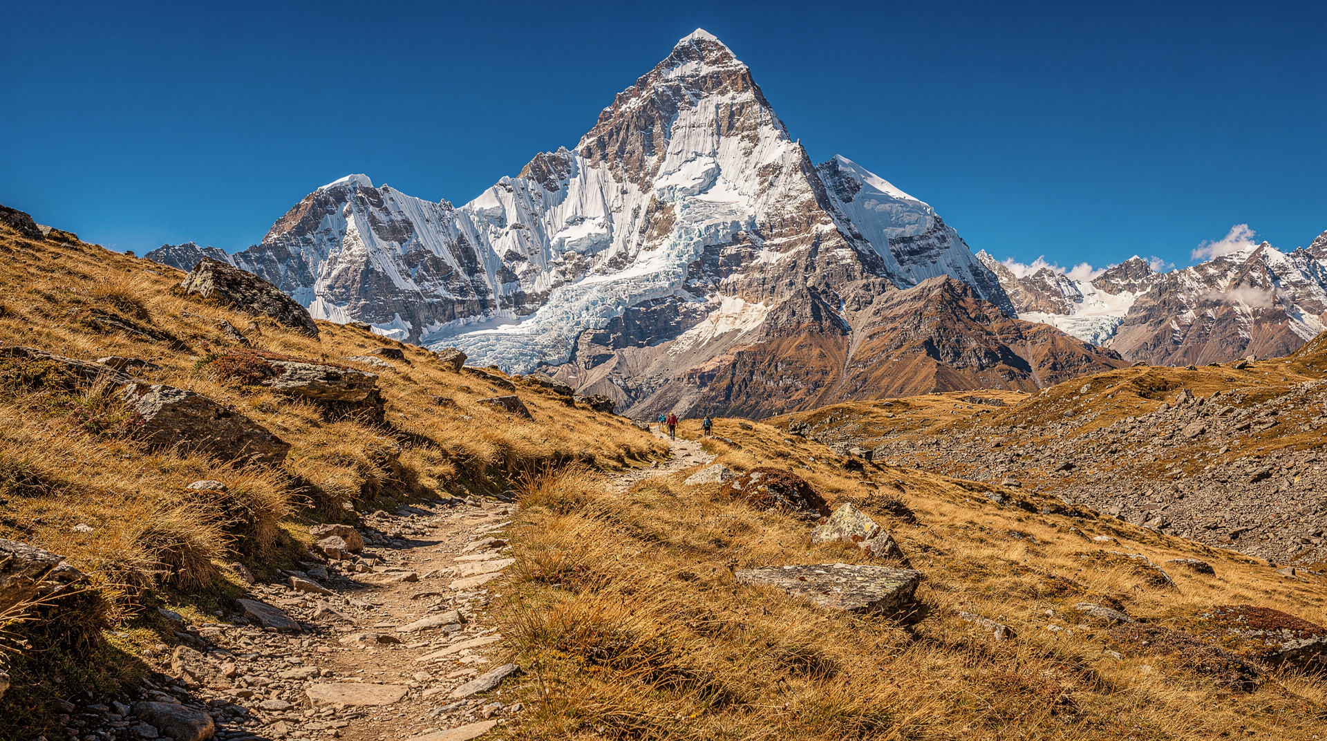
The Salkantay trek to Machu Picchu is not the Inca Trail’s consolation prize — it is a different experience that many experienced trekkers rate more highly. Where the Inca Trail is a guided, permitted, regulated journey on a paved Inca road, Salkantay passes through wilder terrain, fewer crowds (particularly in the high-passes section), and beneath the 6,271-m glaciated bulk of Salkantay peak itself — one of the most dramatic mountain presences in the Andes.
The practical advantages are significant: no permit is required, meaning you can book much closer to your departure date. The trail does not close in February. And the price is often 20–30% lower than the classic Inca Trail for a comparable level of camp organisation.
The trade-offs: fewer Inca ruins along the route (though the Llactapata viewpoint and the final day at Machu Picchu are the real prizes), and a higher maximum elevation — the Salkantay Pass reaches 4,630 m, compared to 4,215 m on the Inca Trail’s Dead Woman’s Pass. This is not a beginner’s route. The complete Salkantay guide covers training requirements, seasonal timing, and the 4-day alternative.
| Distance | around 74 km over 5 days |
| Max altitude | 4,630 m (Salkantay Pass) |
| Permit | none required — book with a licensed operator a few weeks ahead |
| Best season | May–September (dry) |
| Cost | around $400–700 camping, $900–1,500 lodge-to-lodge |
| Getting there | private bus from Cusco to Mollepata/Soraypampa, approx. 3 hrs |
No permit required, but booking still needed: No government permit is needed for Salkantay, but the trek passes through areas managed by local communities and the route requires a licensed guide. The classic 5-day Salkantay trek with a registered operator includes all camp equipment, meals, guide, and horses or mules for heavy gear.
Acclimatisation is non-negotiable: Arrive in Cusco at least 48 hours before the trek starts. Two nights in the Sacred Valley (2,800 m) before the trek is ideal. The Salkantay Pass at 4,630 m will be brutal if your body has had no altitude preparation. See acclimatisation in Cusco.
Day 1: Cusco — Mollepata — Soraypampa base camp
Altitude range: 3,400 m (Cusco) to 3,880 m (Soraypampa) Distance: approximately 7 km walking (after transport)
Depart Cusco early (5–6 a.m.) by private bus. The drive to the trailhead at Mollepata or directly to Soraypampa takes approximately 3 hours via the Limatambo road. Some operators begin the walking at Mollepata (2,800 m) for a longer first day; others drive to Soraypampa directly, which gives a shorter but still meaningful afternoon walk.
Soraypampa (3,880 m) sits in a glacial valley below the flanks of Salkantay peak. The turquoise glacial lake of Humantay is a 1.5-hour side hike from camp, and on a clear afternoon it is one of the most beautiful sights on the entire route — a vivid turquoise cirque lake beneath the ice. If you have the energy, take it; most trekkers who skip it regret it. Some operators offer the Humantay Lake day tour as a standalone if you want to preview the landscape before committing to the full trek.
Camp at Soraypampa. Eat well and sleep early — tomorrow is the pass.
Day 2: Soraypampa — Salkantay Pass — Wayracmachay camp
Altitude range: 3,880 m to 4,630 m to 3,600 m Distance: approximately 15 km
The hardest day, by some margin. From Soraypampa, the trail climbs through boulder fields and moraine to the Salkantay Pass (4,630 m). Salkantay peak towers to the right; Humantay glacier fills the valley behind. The climb takes 3–4 hours. Go slowly, breathe deliberately, and let the porters or mules deal with the heavy packs.
At the pass, the temperature drops sharply and wind is frequent — have a down layer accessible. The views of Salkantay’s glaciated face, often within what feels like arm’s reach, are incomparable.
The descent from the pass is dramatic — from cold, treeless puna into increasingly lush cloud forest as you drop 1,000 m over the afternoon. By the time you reach camp at Wayracmachay or Chaullay (around 3,000–3,600 m depending on the operator), the vegetation is tropical and the air thick with moisture. The ecological transition in a single afternoon is one of the defining experiences of this route.
Day 3: Cloud forest — La Playa — Santa Teresa
Altitude range: 3,600 m descending to approximately 1,600 m Distance: approximately 22 km
Day three continues the descent through increasingly dense cloud forest and into the Aobamba valley. The trail passes coffee and fruit farms, hot springs, and small villages. The terrain is entirely different from the high-altitude drama of day two — lush, green, warm, alive with birds.
Most operators route through La Playa (1,900 m) and continue to Santa Teresa (1,700 m) by early afternoon. Santa Teresa has natural hot springs (Cocalmayo, S/20 entrance) that most groups use for a restorative afternoon soak. The contrast with yesterday’s snow-edged pass is startling. Santa Teresa also has basic guesthouses and small restaurants if you prefer a proper bed on night three instead of camp; confirm with your operator whether camping or hostel accommodation is included on this night.
Day 4: Santa Teresa — Hidroeléctrica — Aguas Calientes
Altitude range: 1,700 m to 2,040 m Distance: approximately 14 km
From Santa Teresa, the route continues down to the Urubamba valley and the Hidroeléctrica hydroelectric station. Most operators take transport (a short minivan ride) from Santa Teresa to Hidroeléctrica — the road is an efficient connection. From Hidroeléctrica, the path runs alongside the PeruRail track for 3 km on a flat, forested trail to Aguas Calientes. This final 90-minute rail-side walk is a gentle, satisfying finish to the trekking section before the main event tomorrow.
Check into your accommodation in Aguas Calientes. This is the town at the base of Machu Picchu — a narrow gorge-bottom settlement of restaurants, hostels, and souvenir shops. It is functional rather than charming, but after four days of camping it feels luxurious. Your operator should arrange or assist with Machu Picchu entrance tickets; confirm your timed circuit entry for the following morning.
Eat a proper dinner tonight — the restaurants one street back from the main avenue charge half the price of the Avenida-facing places for the same food. Sleep early. The morning comes quickly.
Day 5: Machu Picchu — return to Cusco
Altitude range: 2,040 m to 2,430–2,700 m (citadel)
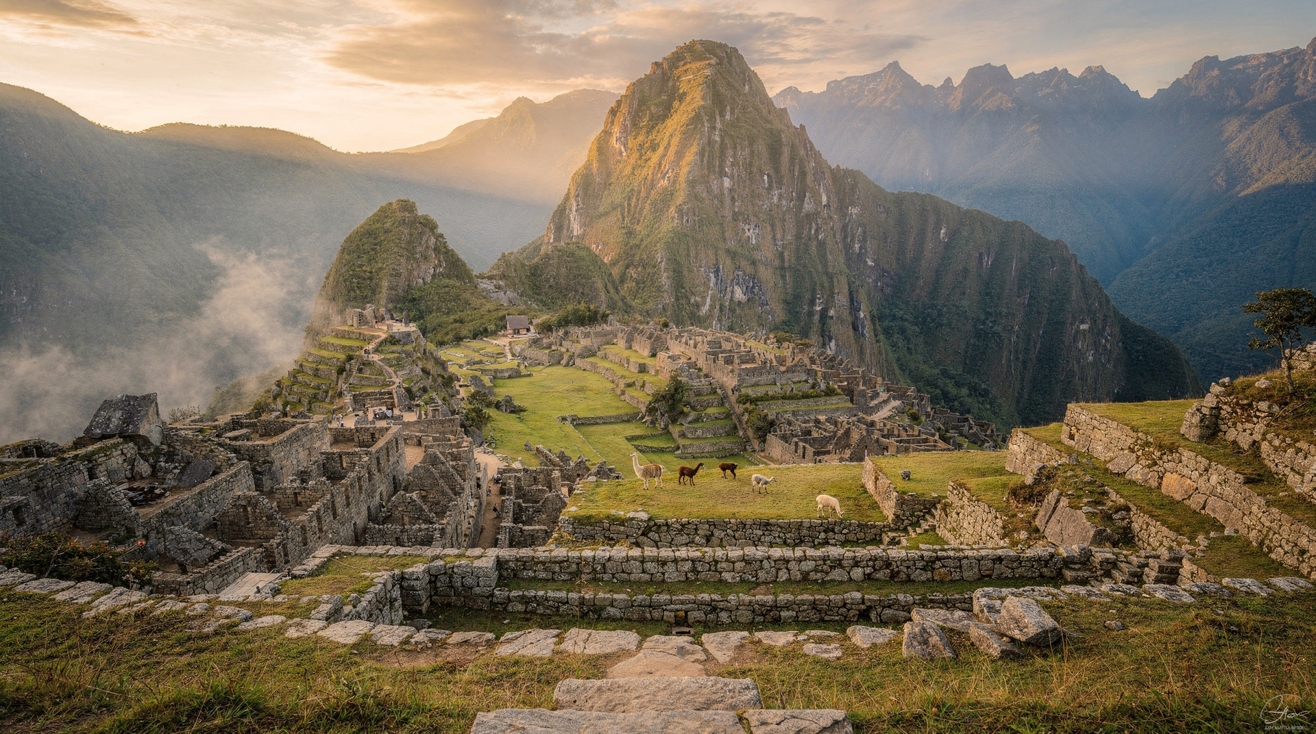
First bus from Aguas Calientes departs around 5:30 a.m. Take it. Your timed entry to the citadel determines your start position, but arriving early puts you ahead of the larger day-trip groups from Cusco. On the full Salkantay package, your guide accompanies you into the citadel for the circuit walk, providing historical context for what you are seeing after four days of pre-Inca Andean landscape.
Allow two to three hours minimum inside Machu Picchu. By midday, descend by bus to Aguas Calientes, have lunch, collect bags from your accommodation, and take the train back to Ollantaytambo (1.5 hours). The return bus from Ollantaytambo to Cusco takes another 90 minutes. Most trekkers are back in Cusco by early evening of day five, exhausted and deeply satisfied.
Optional 4-day version: The 4-day 3-night Salkantay route compresses the itinerary by combining some stages, making it more suitable for those with tighter schedules. Days 3–4 are merged, typically using transport between La Playa and Hidroeléctrica to save the full forest walk. See Salkantay trek guide for the stage-by-stage comparison.
Costs
| Item | Cost (USD approx.) |
|---|---|
| 5-day Salkantay operator package | $400–700 |
| Machu Picchu entrance (~S/152) | ~$41 |
| Aguas Calientes bus (return) | $19 |
| Train Aguas Calientes–Ollantaytambo | $30–55 |
| Tips (guide, porters, cook) | $50–80 |
Total per person: $540–895 USD. Compared with the classic Inca Trail ($650–1,100+ all in), Salkantay is typically $100–200 cheaper at equivalent quality. At the budget end, basic shared-camp operators start around $300 — but scrutinise food quality and horse welfare before booking on price alone.
Tips
Dry season priority: Rain on the descent days (3–4) makes the cloud-forest trails genuinely slippery and unpleasant. Dry season (May–September) is strongly preferred. The Salkantay does not close in February, but January–March is the worst window for conditions.
Physical preparation: Train specifically for steep descent — the Salkantay Pass descent involves 1,000 m of altitude loss in a few hours. Knee problems are more common on day two than altitude problems. Trekking poles are strongly recommended.
Inca Trail vs Salkantay decision: The honest comparison is at Inca Trail vs Salkantay. In brief: the Inca Trail gives you more Inca ruins and a more structured experience; Salkantay gives you wilder scenery and flexibility. Both finish at Machu Picchu, which is what most people actually came for.
What to expect at the Salkantay Pass
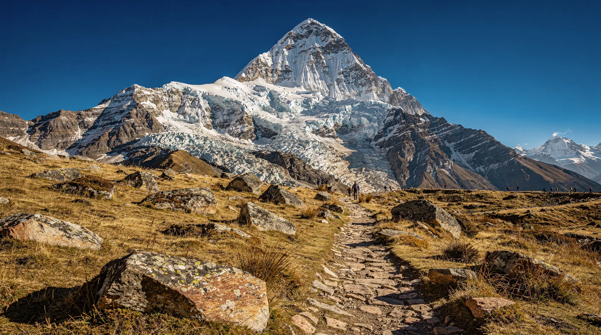
The Salkantay Pass (4,630 m) is the defining moment of this trek and deserves its own description. The approach from Soraypampa climbs through moraine deposited by the retreating Salkantay glacier — a field of boulders and scree that makes the last hour of the climb technical enough to require attention. The glacier itself has retreated significantly since the 1980s; what you see today is roughly half the ice mass that greeted trekkers two decades ago, with exposed brown rock on the upper flanks that was white in older photographs. This is visually striking in a melancholy way and worth noting as you pass.
At the summit (identifiable by the apacheta — the stone cairn pile where trekkers add a stone for good luck and safe passage), the temperature on a clear morning is typically 0–5°C regardless of the season. Wind is frequent and cold. The view of Salkantay peak from the pass — almost directly below the glaciated southwest face at close range — is one of the most dramatic mountain perspectives in Peru. The peak (6,271 m) is one of Peru’s highest and one of the Andean world’s most sacred mountains in Quechua belief; it is an Apu, a mountain deity, still the object of ceremonial offerings from surrounding communities.
The descent from the pass drops 1,000 m over approximately 3 hours. The first half is on loose, steep scree that requires trekking poles for most people; the second half enters increasingly dense cloud forest where the path becomes softer and the temperature rises measurably with every 100 m of descent. The ecological transition on this single descent — from glacier moraine at 4,630 m to lush cloud forest at 3,200 m — is the defining visual drama of the Salkantay route and the aspect most often cited by returning trekkers as the unexpected highlight.
Camping versus lodges
The classic Salkantay trek is offered in two main configurations: a traditional camping format (tents and sleeping bags carried by mule and set up by the camp crew) and a lodge-to-lodge format on a network of purpose-built Salkantay lodges run by a small number of operators (Mountain Lodges of Peru is the best-known). The lodging option costs significantly more — typically $900–1,500 USD versus $400–700 for camping — but provides hot showers, proper beds, and drying facilities for wet gear each evening.
For most mid-range trekkers, the camping format is entirely adequate. The camp equipment brought by good operators (sleeping tents, dining tents, foam mats, and on colder nights, extra blankets) is sufficient for the temperatures encountered between Soraypampa (3,880 m) and the lower camps. The lodge option makes most sense for travellers who are uncomfortable with camping in any form, for mixed groups where one person has a significantly lower tolerance for basic conditions, or for those trekking in the wet season when dry accommodation at the end of a rain-soaked day is particularly valuable.
Acclimatisation days before the trek
The two days before the Salkantay trek begins are more important to the experience than most trekkers realise. Arriving in Cusco the day before departure with no altitude adjustment is common; it is also the single biggest predictor of a miserable pass crossing on day two. The 4,630 m summit hits hardest when your body has had fewer than 48 hours at altitude.
The ideal preparation: arrive in Cusco two full days before the trek departs. Day one: Sacred Valley (2,800 m) — the Ollantaytambo ruins and the market at Pisac. Day two: a gentle Cusco day — Qorikancha, San Blas, and a flat walk around the historic centre.
The combined effect of two nights of graduated altitude (2,800 m then 3,400 m) before the 4,630 m pass means the summit, while still physically demanding, arrives in a body that is adapting rather than still in shock. See how to acclimatise in Cusco and how altitude actually affects the body for the full plan.
Choosing an operator
Not all Salkantay operators are equal, and the price spread ($300 budget to $1,500 lodge-to-lodge) reflects real differences in food quality, mule welfare, guide training and group size. Book with an agency registered with Peru’s tourism ministry rather than a walk-in street tout — the unlicensed operators that circulate around the Plaza de Armas are the same ones behind the tourist-agency scams worth knowing about.
A legitimate operator will have insurance for trekkers, a first-aid kit and oxygen carried on the trek, and will not push you to decide on the spot. If this is one leg of a longer Peru trip, it is worth reading what a realistic Peru trip actually costs before comparing quotes, since the cheapest Salkantay package is rarely the cheapest trip overall once food and horse-welfare corners get cut.
What to pack for the altitude and climate swing
Salkantay is unusual among treks in the range of conditions it covers in five days: near-freezing wind at the 4,630 m pass, then humid, insect-heavy cloud forest by day three. Layering matters more than any single piece of gear — a warm base layer and down jacket for the pass, a rain shell for the cloud-forest afternoons, and lightweight, quick-drying clothes for the lower camps.
What to pack for the Inca Trail covers the same climate range and applies almost item-for-item to Salkantay. Coca tea, offered at every camp, and other altitude remedies are covered in coca tea and altitude remedies — useful reading before day two specifically. Trekking poles, a decent headlamp, and a dry bag for camera gear during the cloud-forest section are the items trekkers most often wish they had packed.
Salkantay versus the train-only route to Machu Picchu
Not everyone should trek. If your priority is simply reaching Machu Picchu with minimal physical risk, the train-only route from Ollantaytambo gets you there in 90 minutes instead of five days, with no altitude pass and no camping. Salkantay is worth choosing over the train specifically for the mountain scenery and the sense of earning the citadel on foot — if that appeal doesn’t outweigh five days of physical effort and camp conditions, the train (or the shorter 2-day Machu Picchu day trip) is a completely legitimate way to see the same ruins.
The 5 days at a glance
| Day | Route | Altitude | Distance |
|---|---|---|---|
| 1 | Cusco → Mollepata → Soraypampa | 3,400 m → 3,880 m | ~7 km |
| 2 | Soraypampa → Salkantay Pass → Wayracmachay | 3,880 m → 4,630 m → 3,600 m | ~15 km |
| 3 | Cloud forest → La Playa → Santa Teresa | 3,600 m → 1,600 m | ~22 km |
| 4 | Santa Teresa → Hidroeléctrica → Aguas Calientes | 1,700 m → 2,040 m | ~14 km |
| 5 | Machu Picchu → return to Cusco | 2,040 m → 2,430–2,700 m | — |
Top experiences
Bookable activities with verified prices and instant confirmation on GetYourGuide.