Inca Trail trip report: four days, honest account
Day zero: Kilometre 82, before anything has started
We gathered at Kilometre 82 — the official start of the classic Inca Trail — at half-past six in the morning, eleven of us from six different countries, all nervous in a way that people pretend not to be when they have been anticipating something for months. The porters were already there, twenty-two of them, coiling ropes and redistributing loads with the efficient calm of people who have done this many times. Our guide, a compact man from Chinchero named Edwin, walked us through the rules: stay together, drink water, do not touch archaeological structures, tip the porters generously at the end.
| Distance | Approximately 43 km over 4 days |
| High point | Dead Woman’s Pass, 4,215 m |
| Permit | Required months ahead, licensed operator only |
| Nights | 3 nights camping, arrival at Machu Picchu on day 4 |
| Closed | The entire Inca Trail network closes each February |
The Inca Trail from Kilometre 82 to Machu Picchu covers approximately 43 kilometres over four days, crossing three mountain passes and passing through multiple Inca archaeological sites before arriving at the Sun Gate above Machu Picchu. It requires a permit, purchased months in advance during peak season, and must be done with a licensed operator and guide. The permit booking process is the part most people underestimate — permits sell out in January for the following high season.
At Kilometre 82, none of that bureaucratic history mattered. The checkpoint was behind us, packs on backs, the first Inca wall already visible across the river. Edwin pointed uphill and we started walking.
Day one: The warm-up that is not actually warm
The first day is widely described as easy. It is easy by Inca Trail standards, which means it is a full day of walking at altitude through varied terrain, involving around 1,000 metres of elevation gain spread across approximately 12 kilometres. If you are not a regular hill walker, this is a full day of work. If you are, it is a pleasant introduction.
The trail on day one follows the Urubamba river valley, passing through Andean scrub and agricultural terraces with views across the river to distant snowfields. The first major archaeological site — Llactapata — appears after two to three hours, a cluster of Inca structures partially restored and surrounded by vegetation. Edwin explained its function as a satellite estate, probably used for agricultural production and as a waystation on the original Inca road network.
Camp at the end of day one sits at around 3,000 metres in a flat river meadow. The tents were already pitched when we arrived. The porters, who had passed us two hours earlier at a half-jog under 25-kilogram loads, had set up camp, prepared hot water for washing, and were starting dinner. This arrangement — which I had read about but not quite believed — is genuinely difficult to take in. They run. With huge loads. At altitude. And arrive before the trekkers who are carrying only a day pack.
Day two: Dead Woman’s Pass and the honest account
Day two is the day people have read about before they start. The trail climbs from approximately 3,000 metres to Dead Woman’s Pass (Abra de Huarmihuañusca) at 4,215 metres in around 6 kilometres of near-continuous ascent. The pass is the highest point of the entire trail.
I will not pretend this is enjoyable while it is happening. The altitude makes the climbing disproportionately exhausting — each step at 4,000 metres requires more effort than the same step at sea level, and the trail’s stone paving (original Inca paving, still largely intact) means there are no soft sections. The last hour before the pass involves a relentless zigzag that appears to end several times but does not.
The view from the top makes it worth it. On a clear day — I was lucky with clear weather — you can see back down the valley you have climbed and forward into the valley you will descend, with snow peaks visible in every direction. Edwin appeared beside me at the top looking entirely unruffled and said something about the pass’s name meaning the mountain looks like a woman lying on her back, which it does.
The descent to the second camp is steep and hard on the knees. Trekking poles are useful here in a way they are not always.
A classic four-day Inca Trail permit and guide is the only legitimate way to walk this trail — independent trekking is not permitted, and licensed operators are strictly managed. The quality of the porter welfare and camp setup varies between operators; this matters more than most pre-trip reading suggests.
What the porters carry, and why it matters
I mentioned the porters running past us with 25-kilogram loads, and it is worth dwelling on. Peruvian regulation caps porter loads at 20 kg (excluding their own kit), enforced with checkpoint weigh-ins, though enforcement varies between operators. The good operators — the kind worth paying slightly more for — provide proper boots, weatherproof tents for the crew separate from client tents, and adequate food.
Edwin told me, on the second night, that he had worked for outfits early in his career that did none of this, and that choosing an operator on price alone is choosing against the people who make the trek physically possible for you. It is one of the few times on a trek where the ethical choice and the practical choice — a well-run operator generally also runs a smoother trek — line up completely.
Day three: The archaeological day
Day two is the hardest physically. Day three is the hardest to do justice to in writing. The trail crosses a second pass at 3,998 metres, descends through increasingly dense cloud forest, and passes through three major Inca archaeological sites — Runkurakay, Sayacmarca and Phuyupatamarca — each one different in character, each one demonstrating something different about Inca building technique and site selection.
Sayacmarca is the one I remember most clearly: a site occupying a narrow promontory above the cloud forest, only accessible through a single narrow staircase. The walls are tight and well-preserved, the drops on either side vertiginous. Edwin explained that the name means “town that is hard to access” in Quechua, which is accurate.
The cloud forest on day three is also, independently of the archaeology, one of the most beautiful environments I have walked through. Orchids growing from tree branches, bromeliad clusters, mist moving through enormous ferns, the trail itself sometimes only a metre wide between walls of green. The contrast with the high-altitude moorland of day two is dramatic.
Camp on day three is at Wiñay Wayna, where a large terraced Inca site clings to the steep hillside above the site. At night the valley below fills with cloud and the campfire circle with other trekkers is an unexpectedly good social moment.
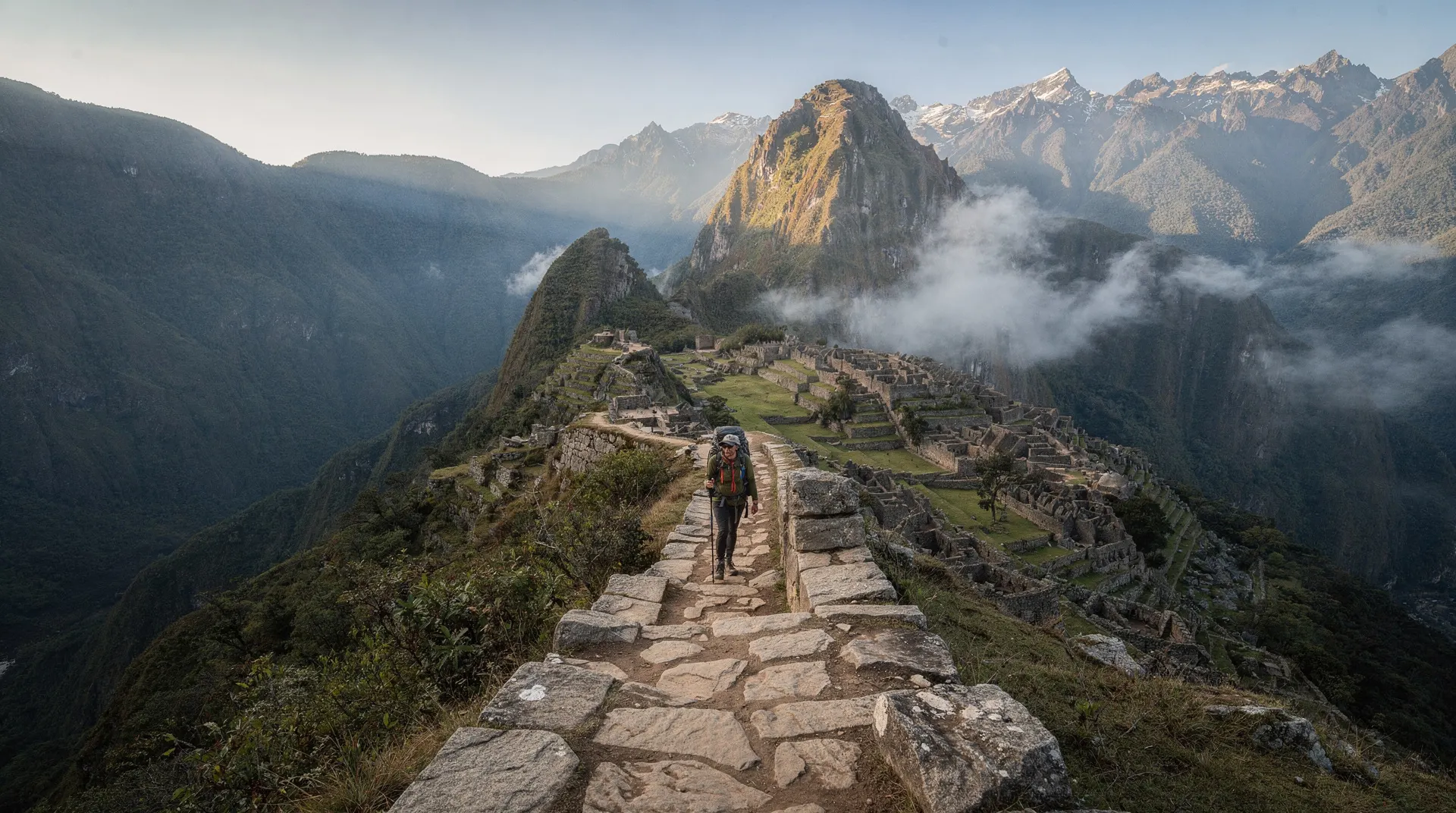
Day four: The Sun Gate at sunrise
We left Wiñay Wayna at 3:30 in the morning for the final section to the Sun Gate — Inti Punku — timed to arrive at dawn. The last stretch of trail in darkness, with headtorches and the smell of damp vegetation, and then the light coming up behind the mountains as we climbed the final staircase.
The Sun Gate at dawn with Machu Picchu visible below in early mist is, as advertised, extraordinary. The photographs I have seen of this view are accurate and they still do not prepare you for what it feels like after three days of walking to get there. I sat on the stone terrace for longer than was sensible given that it was cold and we needed to descend to the main site.
The Inca Trail vs Salkantay comparison is a question worth engaging with seriously before booking. Both routes are genuine and both are recommended for different reasons. The Inca Trail has the archaeology and the Sun Gate arrival; the Salkantay has higher peaks, more dramatic scenery and is available when the Inca Trail is closed in February.
What I would do differently
Poles from day one. I borrowed them from a fellow trekker on day two and they made the steep sections significantly easier. Bring your own or confirm they are available to rent from your operator.
More camera memory than I thought I would need. Day three in the cloud forest generated more photographs than the previous two days combined.
Less anxiety about fitness in the months before. I worried about whether I was fit enough and this worry was not useful — the trail requires walking stamina rather than running fitness, and anyone who walks regularly and allows for altitude adjustment can complete it.
The four days on the Inca Trail are difficult to describe to someone who has not done them because the combination of physical effort, altitude, extraordinary landscape and ancient engineering is not a combination that appears often. I came off the trail tired, slightly sunburned, and more impressed than I had expected to be. That is probably the right result.
Getting fit enough, honestly
I trained for three months beforehand — mostly hill walking on weekends and some stair-climbing sessions — and in hindsight over-worried about pure fitness. What the trail actually demands is walking stamina at altitude, which no amount of sea-level gym work fully prepares you for. Arriving in Cusco at least three to four days before the trek start, following the acclimatisation plan, made more practical difference than the training itself. If you can walk for six to eight hours on varied terrain without a specific pace requirement, and you give your body time to adjust to the altitude first, you are prepared enough.