Moray: the Inca agricultural terraces explained
Sacred Valley: Pisac, Ollantaytambo, Chinchero with Lunch
The terraces of Moray
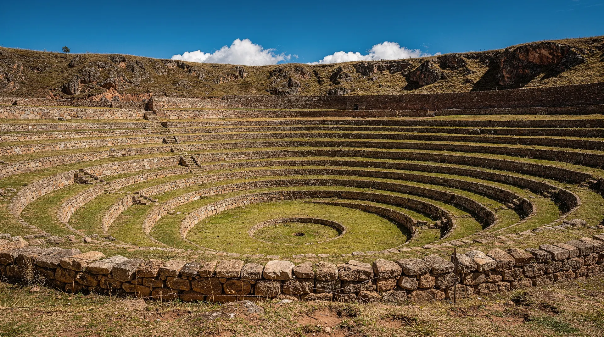
Moray is a site of three large circular bowl depressions in the Sacred Valley plateau, each lined with concentric Inca agricultural terraces. The largest bowl is 30 m deep. Entry requires the full Boleto Turístico (S/130) or Circuit III (S/70). It is almost always visited with the nearby Maras salt mines, 7 km away. Allow 45 minutes to 1 hour at Moray itself.
Circles in the earth
| Where | Sacred Valley plateau, ~50 km from Cusco |
| Cost | full Boleto Turístico (S/130) or Circuit III (S/70) |
| Time needed | 45–60 minutes at the site |
| Altitude | ~3,500 m |
| Pairs with | Maras salt mines, 7 km away |
Moray sits on the Sacred Valley plateau at about 3,500 m, roughly 50 km northwest of Cusco, and it is one of the most visually arresting Inca sites you will encounter. Three large circular depressions are cut into the plateau, each lined with concentric stone-walled terraces descending in precise tiers to a flat base. The largest bowl is approximately 30 m deep and 220 m across. The visual effect — standing at the rim and looking down at the concentric rings vanishing into the earth — is unlike anything else in the Inca world.
Most visitors spend 45 minutes here and leave with a photograph and a satisfying puzzle: what, exactly, was this for? The honest answer is that the function of Moray remains genuinely debated among archaeologists, and the confident explanations you will find on tour leaflets and travel websites are more certain than the evidence warrants. This guide explains what is known, what is credibly hypothesised, and why the uncertainty is part of what makes the site interesting.
Moray is covered by the full Boleto Turístico (S/130) or the Circuit III ticket (S/70), and is almost always combined with the nearby Maras salt mines. The two make a logical half-day that also stands as one of the best-value combinations in the Sacred Valley.
The agricultural laboratory theory
The most widely cited interpretation of Moray is that it functioned as a sophisticated agricultural research station. The evidence for this is partly structural and partly climatic.
The structural argument: The concentric terrace system creates a gradient of conditions from the exposed plateau rim (high wind, maximum UV, lowest temperatures) to the sheltered base (reduced wind, partial shade, higher temperatures). This gradient is not incidental — it is the designed outcome of the bowl form and the terrace depth. Different crop varieties could be planted at different levels and their performance compared under controlled conditions, with the Inca state extracting the most productive varieties for wider cultivation.
The climatic measurement: Temperature studies conducted in the twentieth century found a difference of up to 15 degrees Celsius between the rim and the base of the largest bowl — a variation equivalent to moving through multiple altitude zones in a horizontal distance of roughly 100 m. In a highland environment where altitude-related temperature differences determined which crops could be grown where, this kind of controlled microclimate variation would have been immensely valuable for an agricultural state managing food production across thousands of vertical metres.
The context: The Inca were sophisticated agronomists. They domesticated and selectively bred dozens of potato varieties, multiple maize cultivars, quinoa, and many other crops for performance at specific altitudes and climate conditions. The mit’a food redistribution system that underpinned the entire empire depended on reliable agricultural output at every level of the Andean environment. A site for testing and optimising crop performance fits directly into the logic of how Tawantinsuyu managed food security.
For the broader context of how Inca agriculture and the mit’a system worked together, the Inca Empire guide for travellers is the most useful background reading.
Competing theories
The agricultural laboratory interpretation is plausible but not proven. Several alternative or complementary theories have been proposed:
Religious and astronomical function: The circular form and the precise alignment of the terraces may have had astronomical significance — the Inca tracked the solstice, equinox, and zenith passage of the sun carefully, and some researchers suggest the bowl orientation aligns with solar events. The presence of a single stone at the centre of the main bowl (now removed) is cited in some sources as a potential gnomon or astronomical marker.
Water management training: The hydraulic engineering of the terrace walls and the drainage system within the bowls is considerable. Some researchers suggest the site may have been used to test and develop water management techniques applicable to larger-scale terrace agriculture elsewhere in the Sacred Valley.
Sacred landscape: The Inca concept of sacred geography (the ceque system of lines and huacas radiating from Qorikancha in Cusco) extended throughout the empire, and natural or unusual landscape features were typically incorporated into the sacred geography rather than ignored. The natural depressions at Moray were likely already considered huacas before they were engineered into terraces.
The honest position is that these theories are not mutually exclusive, that the site almost certainly served multiple purposes simultaneously, and that the archaeological evidence to date does not definitively settle the question. The uncertainty is a feature, not a flaw: Moray is a site that continues to reward thinking about rather than simply accepting the first explanation offered.
The three bowls
The site has three main circular terrace complexes:
The main bowl (Qechuyoc): The largest, deepest, and most photographed. Twelve to thirteen concentric terraces descend approximately 30 m to a flat base. This is where most visitor time is spent.
The middle bowl: Smaller than the main bowl, with the same concentric terrace structure but less depth. The access path from the main bowl to this one passes through a section of plateau that gives a clear sense of the overall spatial layout of the site.
The third bowl: The smallest of the three and the least visited. It is worth the additional 15-minute walk for completeness if you have time.
Water channels run through all three bowls. In the wet season (November–March), the base of the main bowl can be damp and the terrace paths slippery. In the dry season (May–September), the site is drier and the path surfaces are more reliable, though the wind on the plateau can be fierce in the early morning.
Combining Moray with the Maras salt mines
The Maras salt mines — the Salineras de Maras — are 7 km from the Moray site and together the two form one of the most logical half-day excursions in the Sacred Valley. The contrast is part of the appeal: Moray is an abstract, structural puzzle; the salt mines are immediate, colourful, and entirely comprehensible — hundreds of individual pool terraces descending a cliff, each managed by a local family, each gleaming white or pink depending on the light and mineral content.
A Maras and Moray day trip covers both sites from Cusco or Urubamba with transport included. The Boleto Turístico covers Moray; the salt mines charge their own separate entry fee (approximately S/10, not covered by the Boleto).
For visitors incorporating both Moray and the main Sacred Valley sites (Pisac, Ollantaytambo), a full-day Sacred Valley tour covers all four in a single well-paced day. This is the most efficient structure for a first visit to the Sacred Valley from Cusco, allowing a guide to provide context at each site rather than requiring you to research each independently.
What to bring and practical comfort notes
Because Moray sits on an exposed plateau with little natural shelter, the practicalities matter more here than at valley-floor sites. A refillable water bottle, sunscreen reapplied through the visit, and a hat with a chin strap (wind gusts are common) are the basics. There is a small snack and drinks stall near the entrance but no restaurant, so plan lunch either before arriving or after moving on to Maras or back toward Urubamba. Toilets are available at the entrance building; there are none within the site itself. Mobile signal is patchy on the plateau — download any maps or reference material you want before leaving Cusco or Urubamba.
Getting to Moray
From Cusco, two primary routes:
Via Maras village: The most common approach from Cusco. From Cusco’s bus terminal (Pavitos area), shared colectivos run to Urubamba; from Urubamba a separate colectivo or taxi serves Maras village and then Moray. Total journey around 1.5–2 hours each way. A taxi from Cusco to Moray costs approximately $25–40 depending on whether it is combined with the salt mines.
Via Chinchero: Some routes via Chinchero connect to Moray on the plateau above the Sacred Valley. This is less common for independent travellers but works if you are combining Chinchero and Moray on the same day.
On a tour: The most efficient option. Most tours pick up from Cusco hotels and combine Moray with the salt mines and usually one or two further Sacred Valley sites.
Altitude and practical notes
Moray sits at approximately 3,500 m on the plateau above the Sacred Valley floor. This is slightly above the Sacred Valley average but below the elevation of Cusco (3,400 m). The plateau exposure means wind is often a factor — carry a windproof layer even in the dry season.
The walk around the rim of the main bowl and down to the base (if the path is open) is about 1.5 km on uneven stone paths. The descent into the bowl is moderate; the ascent back out is more demanding at altitude. If you are still adjusting to altitude on your first or second day in the region, take the descent slowly and rest at each terrace level before continuing.
Practical summary:
- Opening hours: 7 am–6 pm daily.
- Entry: Full Boleto Turístico (S/130) or Circuit III (S/70).
- Time needed: 45–60 minutes at the site itself.
- Getting there: 50 km northwest of Cusco via Maras; taxi $25–40; or included in Sacred Valley tours.
- Altitude: approximately 3,500 m.
- Nearest companion site: Maras salt mines, 7 km away.
The Sacred Valley complete guide covers how Moray fits into the broader Sacred Valley visit sequence. The one-day Sacred Valley itinerary shows a practical day structure that includes Moray without overloading the schedule.
Modern agricultural research at Moray
Interest in Moray’s original function has moved beyond archaeology in recent years, as agronomists have begun studying the site’s native crop varieties as a genetic resource. Andean potato, quinoa and maize varieties adapted to the specific microclimates found across the terrace rings are of active interest to researchers studying climate-resilient crops for high-altitude agriculture globally.
Some of the varieties still cultivated in small plots on and around the site descend from strains grown in the area for centuries, effectively continuing — in a modern research context — a use the Inca may well have intended. This gives the site a genuine present-day relevance beyond its status as a historical curiosity, and a good guide will often mention it as part of the wider story of Andean crop diversity.
What makes Moray genuinely unusual
Most Inca sites are legible in terms of form and function: a temple looks like a temple, a fortress like a fortress, a terrace system like a terrace system. Moray does not resolve so cleanly, and this is precisely what makes it interesting to a certain kind of visitor. The concentric circles descending into the earth look nothing like any other agricultural structure in the Inca world — they are not found anywhere else in Tawantinsuyu — and the absence of a clear parallel makes interpretation genuinely difficult.
The best approach to Moray is probably the most honest one: accept that the site is extraordinary without needing to attach a definitive explanation to it. The bowl form is precisely built, clearly intentional, and clearly served some important purpose for the Inca state — whether principally agricultural, ceremonial, astronomical, or hydraulic-educational. The fact that four plausible theories all fit the evidence reasonably well suggests that the site served multiple functions simultaneously, which is consistent with how the Inca generally organised sacred and productive landscapes.
For visitors who approach Moray as a puzzle rather than a box to be ticked, it delivers one of the more intellectually satisfying experiences in the Sacred Valley — a site that forces you to think rather than simply to photograph and move on.
A Maras and Moray day trip that gives you time at both sites and a guide who can walk through the competing interpretations of Moray is the best structure for extracting the most from what is, in physical terms, a 45-minute stop but in intellectual terms a much more complex experience.
Frequently asked questions about Moray: the Inca agricultural terraces explained
What was Moray actually used for?
Is Moray covered by the Boleto Turístico?
How do I combine Moray with the Maras salt mines?
Can I walk from the Maras village to Moray?
How deep is the largest bowl at Moray?
Is Moray worth visiting if I am short on time?
Top experiences
Bookable activities with verified prices and instant confirmation on GetYourGuide.
