Choquequirao trek guide: the Inca site almost no one reaches
What is the Choquequirao trek?
Choquequirao is a large Inca ceremonial and agricultural site — sometimes called the sister city of Machu Picchu — accessible only on foot via a hard 4-day round-trip trek (or 5-8 days as part of a longer route to Machu Picchu). The site sees fewer than 40 visitors per day. No permit required. Best for serious trekkers who want a genuinely remote Inca experience.
The Inca city that requires genuine effort to reach
Machu Picchu receives several thousand visitors a day. Choquequirao receives fewer than forty. The comparison is instructive: both sites were built by the Inca in the fifteenth century, both are terraced complexes of ceremonial and agricultural structures in dramatic mountain settings, and both are of major archaeological significance. The difference is the approach. Machu Picchu is accessible by train and bus in a day from Cusco. Choquequirao is accessible only on foot, after a four-day trek that descends into and climbs out of one of the deepest canyons in South America.
The rarity of Choquequirao is not incidental to the experience — it is the experience. The empty plazas, the partially excavated terraces, the absence of souvenir stalls and organised tour groups, and the genuine sense of arriving somewhere that most visitors to Peru will never see are what the trek is about.
This is not a beginner’s route. The Choquequirao trek is physically hard, remote in the sense that medical assistance is hours away, and demands more logistical self-sufficiency than the Inca Trail or Salkantay. For the right traveller, it is the most rewarding multi-day trek in the Cusco circuit. This guide covers what the route involves, what to realistically expect, and whether it is the right choice for your trip.
| Where | Apurimac canyon, trailhead at Capuliyoc near Cachora |
| Cost | Around $200–350 guided (4-day round trip) |
| Time needed | 4 days round trip; 7–10 days if continuing to Machu Picchu |
| Getting there | 3–4 hour bus from Cusco to Cachora/Capuliyoc |
| Permit | None required |
| Best time | May–September (dry season) |
What Choquequirao actually is
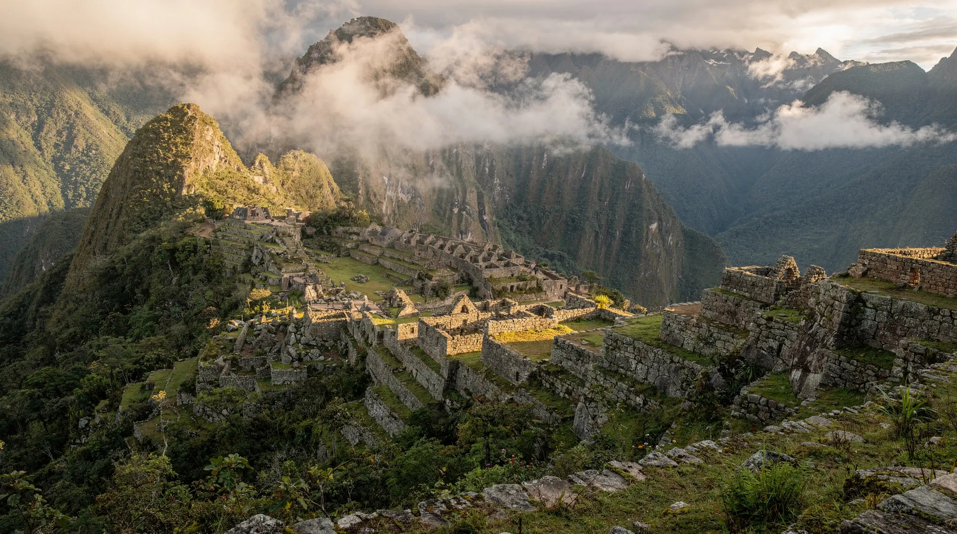
Choquequirao (“cradle of gold” in Quechua) sits at 3,050 m on a high ridge above the Apurimac river, roughly 300 km northwest of Cusco by road to the trailhead. The site was built in the late 15th century, likely under Topa Inca Yupanqui and Huayna Capac, and served as a major administrative and ceremonial centre for the Vilcabamba region — the same area that the last Inca rulers retreated to after the Spanish conquest.
The complex spans over 700 hectares of terracing, plazas, residential structures, and ceremonial baths — making it comparable in scale to Machu Picchu. Only 30–40% has been excavated and partially restored. The rest sits under vegetation, visible as moss-covered mounds and occasional exposed stonework. Walking through the unexcavated sections beside the cleared central plaza gives the site a quality of active discovery that a fully tourist-developed site cannot replicate.
Key structures at Choquequirao include the upper plaza, the Huchuy Llaqta upper sector, the famous llama terrace reliefs (carved llama figures decorating an agricultural terrace wall — unique in Inca archaeology), the religious complex, and an extensive agricultural terrace system descending the ridge into the valley.
The trek: four days, two canyon crossings
The standard Choquequirao round trip is four days from the trailhead at Capuliyoc, near the town of Cachora, approximately 3–4 hours by bus from Cusco.
Day one — Cachora to Chiquisca (2,900 m to 1,800 m, approximately 7 hours)
The day begins with the initial descent into the Apurimac canyon. From Capuliyoc (2,900 m), the trail drops steeply to Chiquisca at around 1,800 m — a 1,100 m descent on a well-maintained but consistently steep path. The canyon is hot at lower elevations; midday temperatures in the 25–30°C range are common even in dry season, and the trail is fully exposed on much of the descent.
The Apurimac river is audible from much of the descent. By camp at Chiquisca, the scale of the canyon is obvious: the walls on both sides rise nearly 3,000 m above the river. The sense of being deep inside a very large geological feature is one of the trek’s distinctive early impressions.
Day two — Chiquisca to Choquequirao (1,800 m to 3,050 m, approximately 8 hours)
Day two descends further to the Apurimac river crossing at around 1,500 m, then begins the 1,500 m ascent to Choquequirao at 3,050 m. This is the hardest day: a canyon-floor heat at mid-morning followed by a sustained uphill climb in direct sun. Most groups start before dawn to cross the canyon bottom before temperatures peak.
The approach to Choquequirao in the final hour follows an Inca-paved path through the lower agricultural terraces, arriving at the main plaza in the afternoon. The first view of the central plaza — cleared, restored, and entirely empty of other visitors on most days — is the moment that justifies the effort.
Overnight at the camp near the site. There is a small campsite and a basic café; no proper accommodation.
Day three — Exploration of Choquequirao
Most guided itineraries dedicate day three to exploring the site. With a full day and a knowledgeable guide, the site reveals itself in a way that a same-day afternoon visit cannot. The llama terrace reliefs on the western agricultural sector are a 20-minute walk from the main plaza and are frequently skipped by groups without a full day. The Huchuy Llaqta upper sector, the ceremonial baths, and the residential complexes in the lower plaza add context to the central plaza visit.
Beyond the cleared sections, walks through the unexcavated outer terraces — where the vegetation cover gives way to occasional exposed Inca stonework — are possible with a guide who knows the boundaries. The scale of what remains unexcavated is immediately apparent and is, for many visitors, more affecting than the cleared sections.
Day four — Return to Cachora (full reverse of the outbound route, 8 hours)
The return follows the same path in reverse: down from the site, across the Apurimac, and back up to Capuliyoc. The uphill from the canyon floor to the trailhead is the final physical challenge, particularly heavy-legged after three previous days of effort. Most groups return to Cusco the same evening or overnight in Cachora.
The longer Choquequirao-to-Machu Picchu route
The Choquequirao trek is also the first section of a 7–10 day trekking route that continues from Choquequirao to Machu Picchu via the Yanama and Santa Teresa valleys — a point-to-point traverse that many consider the finest Andean multi-day trek available. This extended route requires more planning, logistics, and physical preparation than the 4-day round trip.
The Choquequirao-to-Machu Picchu route crosses additional high passes (including a 4,600 m pass above Choquequirao), descends to the Santa Teresa river valley, and connects with the Salkantay trek route in the final days before Aguas Calientes. It is a serious commitment but gives both Choquequirao and Machu Picchu in a single continuous route without backtracking. Most guided versions of this extended trek cost $450–650.
For the best overall comparison of multi-day trekking options — the Inca Trail, Salkantay, Lares, Inca Jungle, and Choquequirao — see the best treks to Machu Picchu guide.
Physical demands: what you need to be prepared for
The Choquequirao trek demands:
- Sustained steep descents and ascents totalling over 4,000 m of elevation change across four days
- Heat at the canyon bottom (1,500 m), which is a physiological challenge different from but comparable in impact to cold and altitude on higher-elevation routes
- Camp conditions (no lodges, no hot showers, no reliable phone signal) for the full four days
- The psychological resilience for a fully remote route where retreat means retracing the same difficult path
Altitude is less extreme than the Inca Trail or Salkantay — Choquequirao’s maximum point at 3,050 m is well below Dead Woman’s Pass or the Salkantay summit. The physical demand here is canyon depth and distance, not altitude. But acclimatisation in Cusco for three nights before starting is still advisable, as the trailhead at Capuliyoc is 2,900 m.
The altitude sickness guide covers acclimatisation advice that applies to the trailhead elevation even if the route itself stays at relatively moderate heights.
Cost
A guided 4-day round-trip Choquequirao trek typically costs $200–350 per person, including:
- Guide
- Mule support (most guided groups use mules to carry camping and cooking equipment)
- Camping gear and meals
- Transport from Cusco to the trailhead and return
No permit fee. No government capacity limit. This is a direct reflection of the route’s low visitor numbers and the absence of the government tourism infrastructure that adds cost to the Inca Trail.
Independent trekking to Choquequirao without a guide is possible — the trail is marked, and muleteer services are available in Cachora for hire. It is cheaper and suitable for experienced trekkers with good Spanish and navigation skills. For first-time visitors to the area, a guide adds significant value in terms of route knowledge, safety management, and the ability to explain what you are looking at once you arrive at the site.
What to pack for the Choquequirao trek
The Choquequirao trek’s specific packing considerations are different from higher-altitude routes like the Inca Trail or Salkantay. The challenge here is the canyon heat, not the high-altitude cold.
For the canyon sections (days one, two, and four):
- Lightweight, moisture-wicking clothing: the Apurimac canyon at 1,500 m can reach 30°C in the afternoon. Heavy hiking trousers and thick base layers will be uncomfortable.
- Sun protection: the canyon walls offer limited shade on the main descent paths. SPF 30+ and a sun hat are essential.
The UV at altitude, combined with the reflected heat of the canyon walls, makes sun protection more important than on cloud-covered cloud forest routes.
- 3 litres of water capacity: the water sources on the descent are limited. Carry sufficient from camp, with filtration for stream water. Running low on water at the canyon floor is a serious issue in high temperatures.
- Insect repellent: mosquitoes are present at the lower canyon elevations, particularly near the river.
For the site and higher elevations:
- A fleece or light insulation layer for the evenings at Choquequirao camp (3,050 m). The contrast between the canyon heat and the ridge-top cool at night is significant.
- Trekking poles: the canyon descent sections are steep. Without poles, the downhill is harder on the knees and the uphill return on day four is harder on the quads.
Photography:
- The llama terrace reliefs on the western agricultural sector are the photographic highlight of the site. The late afternoon light on day two or the early morning of day three gives the best angles on these carvings. Plan the site visit accordingly — do not leave the western sector for last when you are tired.
- Dust is present on the dry trail sections in May–September. Camera bags with a dust cover or a lens cloth are useful.
When to go
May–September is the recommended window, strongly preferred for the canyon sections. The descents and the canyon floor crossing in wet season (November–April) can be slippery, and the Apurimac river can run high enough to make the crossing more hazardous. Canyon heat is present year-round; dry season keeps the trail firm.
The site itself is stunning year-round. Dry season gives clear views of the Salkantay and surrounding peaks from the site’s upper sectors. The lack of vegetation around the cleared plazas is consistent regardless of season. Wet season does have one advantage — the vegetation on the unexcavated sections of the site is greener and the contrast with the cleared stonework is more vivid. But the canyon crossing risk in wet season argues strongly for a May–September window.
The cable car question
Plans to build a cable car to Choquequirao have circulated for years. A cable car would reduce the journey to the site from a four-day trek to a half-day excursion, and visitor numbers would increase from dozens to potentially thousands per day — transforming the site’s character entirely.
As of June 2026, the cable car has not been built. Whether or when it will be completed is uncertain. Travellers who specifically value the remote, uncrowded character of Choquequirao should be aware that this could change and plan their visit accordingly. The four-day trek exists now and delivers a category of experience — a major Inca site with almost no other visitors — that may not exist at this scale indefinitely. If your Cusco trip is in the planning stages and Choquequirao is on the list, sooner is better than later.
For context on how Choquequirao fits into the broader range of Cusco trekking options, see the best treks to Machu Picchu guide — though Choquequirao is distinct in that it does not end at Machu Picchu on the standard four-day format. It is not a route to Machu Picchu; it is a route to one of Peru’s most significant and least visited Inca sites, which is a different but equally valid reason to trek.
For serious trekkers who have already done the Inca Trail and want the next level of remote Inca archaeology, Choquequirao is the natural next destination.
Water, food and the mule-support system
Because there is no lodge, café or reliable resupply point along the four-day route beyond a single basic snack stall near the site itself, the trek relies entirely on the mule-support system that guided operators organise. Mules carry tents, cooking equipment, food supplies and often trekkers’ larger bags, while trekkers themselves carry only a daypack with water, snacks, camera gear and layers for temperature changes across the day.
Meals are prepared by a dedicated cook at each campsite — breakfast and dinner hot, lunch often a packed or trailside meal depending on the day’s schedule. Water for drinking is typically boiled or filtered from local sources by the guide team rather than carried in full from Cachora, though trekkers should still carry a full 3-litre capacity and treat any water they source independently. Independent trekkers without mule support must carry everything themselves across the same elevation profile, which meaningfully increases the physical demand of an already hard route.
Choosing a guide for a remote route
Because Choquequirao has no permit system and no government infrastructure comparable to the Inca Trail, the quality of your trek depends almost entirely on the operator you choose — there is no external body checking guide certification or mule-welfare standards on this specific route the way there is on the regulated trail.
Ask prospective operators directly about group size, mule loading limits, guide first-aid certification, and evacuation planning for the remote canyon sections, where the nearest vehicle access is a full day’s walk away in either direction. The unlicensed tour agencies guide covers the questions worth asking before paying a deposit for any trek in the region, and it applies with extra weight here given the remoteness.
Mobile signal and staying in touch
One of the more overlooked practical realities of the Choquequirao trek is the near-total absence of mobile signal for the full four days once you leave Cachora. Some ridgelines occasionally catch a faint signal from distant towers, but this is unreliable and should not be counted on for check-ins with family or work. Travellers who need to communicate on a schedule should arrange this before departing — informing contacts that you will be unreachable for four days is standard practice for this route, unlike shorter day trips or even the Inca Trail, where brief signal pockets are somewhat more common near campsites.
How Choquequirao compares to the Inca Trail experience
Visitors who have done the Inca Trail and are considering Choquequirao often ask how the two compare beyond the visitor numbers. The Inca Trail’s appeal is partly archaeological (Sayaqmarka, Phuyupatamarka, Wiñay Wayna along the route) and partly the Sun Gate arrival at Machu Picchu itself. Choquequirao’s appeal is different in kind: the destination site is the payoff, not a series of stops along the way, and the emptiness of the plazas once you arrive is the experience in a way the Inca Trail — busy with other trekking groups even on a good day — cannot replicate.
Physically, Choquequirao is harder in a different way: less altitude, more sustained vertical gain and canyon heat. Neither route is a “better” version of the other; they reward different priorities, and the best treks to Machu Picchu guide covers how all the region’s multi-day routes stack up against each other.