Palccoyo day trip from Cusco
Cusco: Full-Day Palccoyo Rainbow Mountain All-Inclusive Tour
How do you do the Palccoyo day trip from Cusco?
Palccoyo tours from Cusco depart around 4–5 am, drive 3.5–4 hours southeast to the trailhead at about 4,700 m, and walk a gentle 3 km to view three separate coloured ridges at 4,900 m. Tours cost S/90–130 ($25–35 USD). Much less strenuous than Rainbow Mountain Vinicunca and significantly quieter.
Why Palccoyo is the honest recommendation for most visitors
Palccoyo sits in the shadow of its more famous neighbour Rainbow Mountain Vinicunca and suffers for it commercially — almost every tour operator pushes Vinicunca first because it has the brand recognition. This guide pushes back on that.
For the majority of visitors to Cusco — particularly those who are not highly acclimatised, those who find steep sustained climbing difficult, and those who prefer a landscape with some solitude — Palccoyo is the better choice. Three coloured ridges (not one), a shorter and easier walk, 300 m less altitude, far fewer other tourists, and the unusual bonus of a petrified queñoa forest. The colours are the same mineral deposits: iron, sulphur, copper, chlorite. The mountain is the same formation. The experience is quieter and often more moving.
| Where | Palccoyo, Canas province, ~130 km southeast of Cusco |
| Cost | S/90–130 ($25–35) guided tour; S/230–300 private taxi/minivan for up to six |
| Time needed | Full day, roughly 4 am–4–6 pm |
| Getting there | Organised tour or private vehicle only — no public transport to the trailhead |
| Best time | May–September dry season, morning light |
What Palccoyo actually is
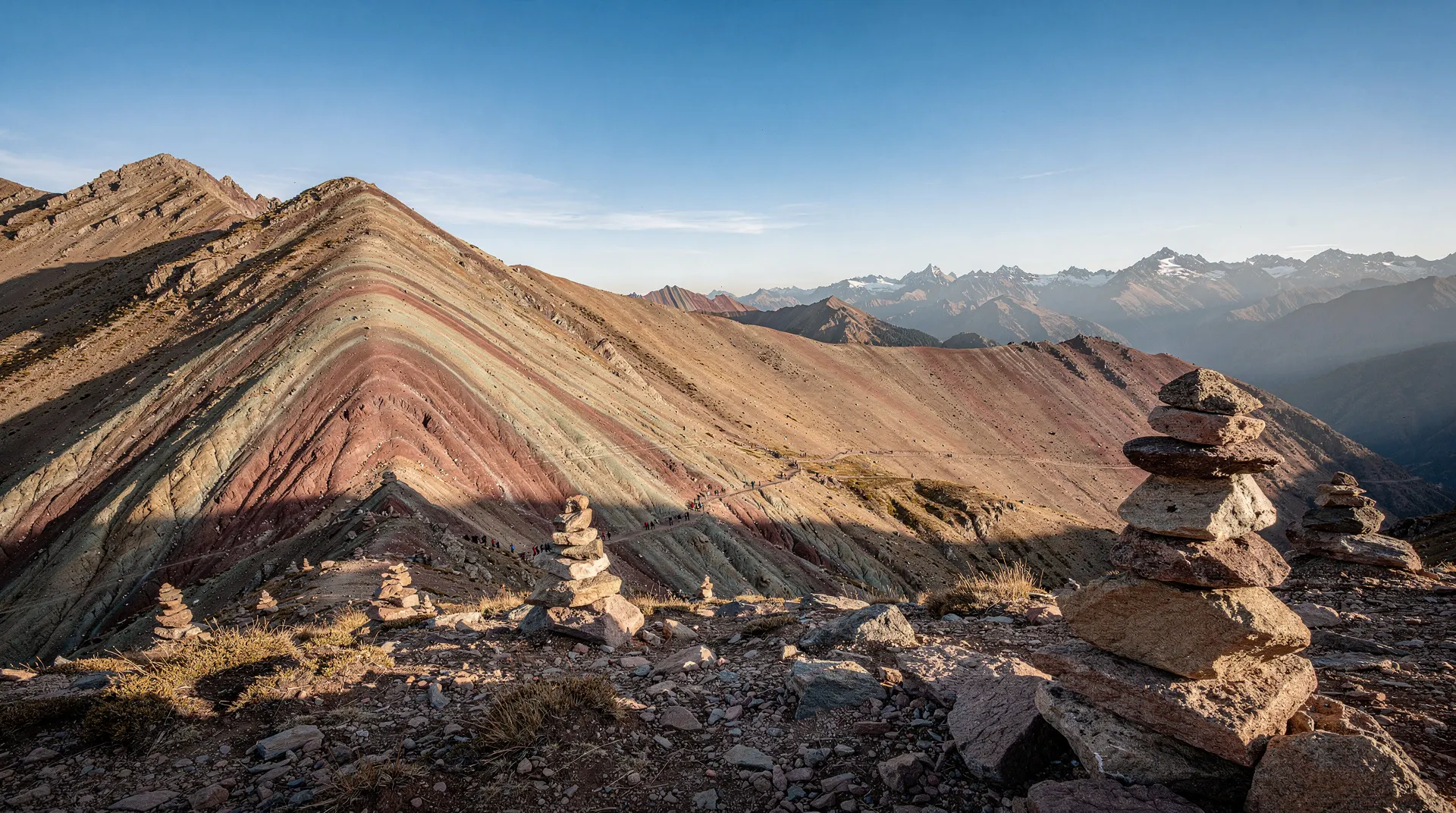
Palccoyo is a mountain range at the southern end of the same geological belt that produces Rainbow Mountain Vinicunca’s famous colours. Three distinct ridges are visible from the main walking trail: Palccoyo itself (the highest at 4,900 m), and two additional formations nearby. Walking the route gives you changing angles on each ridge and the surrounding high-Andes plateau, with the white cone of Apu Ausangate (6,384 m) visible on clear days.
The terrain is high-altitude puna grassland: low cushion plants, ichu grass, grazing alpaca and llama. The queñoa trees — twisted, ancient-looking and draped with lichen — are the other photographic highlight and appear in the middle section of the walk.
Getting to Palccoyo from Cusco
Palccoyo lies approximately 130 km southeast of Cusco, beyond the town of Checacupe in the Canas province. The drive takes 3.5–4 hours along the main Cusco–Puno highway, turning south at Checacupe onto a dirt road for the final section.
Guided tour: The most practical option. A Palccoyo full-day tour from Cusco includes hotel pick-up (typically 4:00–5:00 am), the drive, a breakfast stop en route, a guide at the mountain, a packed lunch, and return transport. Cost: S/90–130 ($25–35 USD) per person. This is comparable to Rainbow Mountain tour prices.
Private transport: A taxi or minivan for the day costs S/230–300 ($63–80 USD) for up to six people. For groups of four or more, this is cost-competitive with individual tour places.
Note: the road beyond Checacupe becomes unpaved and can be bumpy. The drive is longer than to Vinicunca — this is the one practical advantage Vinicunca has over Palccoyo. Accept the longer drive; the crowd difference at the destination more than compensates.
The walk: three ridges and a petrified forest
The trail begins at the community parking area around 4,700 m. The path is well-worn but not crowded — Palccoyo receives a fraction of Vinicunca’s visitor numbers even in peak season. Total walking distance is approximately 3 km with about 200 m of elevation gain spread gently across the route.
First section: A steady gradient through puna grassland, crossing dry stream beds. You pass several llama herders whose animals graze undisturbed by the small number of walkers.
Queñoa forest: Around the 1.5 km mark, the path enters a grove of ancient queñoa trees — polylepis species that grow above 4,500 m and are among the highest-altitude trees on earth. Their bark peels in red-orange curls, their trunks twist into impossible shapes, and the whole grove has an otherworldly atmosphere that stops most walkers.
First ridge viewpoint: The initial coloured ridge appears at around the 2 km mark, offering the first good view of the mineral-streaked slopes. This is often where Palccoyo guides suggest pausing.
Main viewpoint: A further 500 m brings you to the primary viewpoint where all three ridges are visible simultaneously. The panorama also takes in the snow-capped peaks of the southern Cusco Andes, including Apu Ausangate. This is the spot to spend 20–30 minutes and have the packed lunch if conditions allow.
Return: The same path back, or a loop variant that some guides use. Total walking time: 2–2.5 hours.
Altitude at Palccoyo
At 4,900 m for the summit viewpoint, Palccoyo is still genuinely high. The altitude comparison with Vinicunca (5,200 m) is real but should not give false confidence. You will feel altitude at 4,900 m, especially exerting yourself on even gentle gradients.
The critical difference: Palccoyo’s path has no steep sustained climbs. Vinicunca’s path gains 300 m in a steep push from 4,900 m to 5,200 m; that final stretch is where altitude symptoms typically escalate for visitors. Palccoyo simply does not ask that of you.
Still recommended: two nights in Cusco or the Sacred Valley before attempting Palccoyo. Read the altitude sickness guide for preparation advice.
What to pack
The packing list for Palccoyo is standard for a high-altitude Andean day:
- Warm jacket and gloves (temperatures often below 10°C at the viewpoint)
- Waterproof outer layer (the sky at 4,900 m changes fast)
- Sun protection: SPF 50+, sunglasses, wide-brimmed hat
- Two to three litres of water
- Snacks in addition to tour food
- Sturdy walking shoes or trekking boots
- Small soles for the community entrance fee (~S/10) and tips
Palccoyo versus Vinicunca: the honest summary
Palccoyo wins on: ease of walk, altitude, crowds, solitude, the queñoa forest, multiple ridges versus one. Vinicunca wins on: brand name recognition, the single iconic striped mountain image, slightly shorter drive from Cusco.
The one situation where Vinicunca genuinely beats Palccoyo: you are highly acclimatised and specifically want the famous striped-mountain summit photograph. For everyone else, Palccoyo is the honest recommendation.
The full Vinicunca vs Palccoyo comparison guide covers this in more depth with more nuance. The Rainbow Mountain complete guide covers Vinicunca for those who have decided they want the original.
Combining with other excursions
Palccoyo can be combined with the Ausangate lakes route if you have a full free day and a private vehicle — the two areas are in the same general direction from Cusco, though the full combination is a long day. Ask your tour operator about this specifically. An Ausangate lakes and ATV day trip covers the same general area at a different pace if you would rather add a second high-altitude excursion later in your trip than combine both into one very long day.
For a gentler trip sequencing: Sacred Valley on day two (lower altitude, easy), Palccoyo on day three (well-acclimatised by then, manageable altitude), Machu Picchu on day four or five. This is a natural and well-paced progression.
The drive to Palccoyo: what you see on the way
The route from Cusco to Palccoyo follows the main Cusco–Puno highway southeast for around 90 km before turning south into the Canas province. The drive itself offers a gradual transition from the city’s periphery into the high puna grassland that occupies most of the Cusco department beyond the Urubamba and Vilcanota valleys.
The highway passes through the town of Checacupe at around the 90 km mark — worth noting because the Checacupe church has an unusual collection of colonial paintings and the town sits at the junction of several significant rivers. Beyond Checacupe the road becomes unpaved and the landscape opens into vast rolling grassland dotted with the characteristic straight thatched huts of the Quechua communities of the high puna.
Herds of alpaca and llama are common along the route. In the early morning, the light on the open grassland and distant snow-capped peaks is dramatically clear; this is one of those drives where looking out of the window is not merely something to do between destinations.
The queñoa trees: polylepis at altitude
The queñoa trees (polylepis species) at Palccoyo are among the ecological highlights of the entire Cusco day-trip circuit, and they receive far less attention than they deserve. Polylepis are the highest-altitude trees on earth, growing at elevations where essentially no other tree species can survive. They colonise rocky hillsides and sheltered bowls between 3,500 m and 5,000 m, their bark peeling in papery red-orange sheets to shed ice and snow.
The Palccoyo queñoa grove sits at around 4,800 m. The individual trees are old — growth at this altitude is measured in millimetres per year — and some are probably several hundred years old. The twisted, lichen-draped forms they develop in response to permanent wind and cold give the grove an atmosphere unlike any other forest in Peru. Many visitors rate the queñoa grove as more moving than the coloured ridges.
The polylepis forests of the high Andes were once far more extensive and were dramatically reduced by human cutting for fuel. Conservation programmes have restored some areas; the grove at Palccoyo is a surviving fragment of what was once a widespread high-altitude ecosystem.
Community life at Palccoyo
The area around Palccoyo is inhabited by Quechua communities of the Canas province who maintain traditional pastoralism — herding alpaca and llama on the high puna — alongside increasingly tourism-related activities. The community entrance fee (S/10) goes directly to community funds; the family households near the trailhead sometimes sell chicha (fermented maize drink), snacks and simple handicrafts.
Taking time to acknowledge the herders and their animals on the trail — rather than walking past with headphones in — is the most basic courtesy. The horses and their handlers who provide the optional riding service are community members; the going rate for horse hire (S/40–60) is a significant portion of a daily income and is not an area for aggressive negotiation.
Seasonal conditions at Palccoyo
The dry season (May–September) gives the most reliable conditions: clear skies, firm paths, and the best photographic light. The mineral colours of the ridges are not affected by season — they are permanent geological features — but overcast skies reduce contrast and make the colours appear muted.
The wet season (November–March) brings afternoon rain and occasional morning cloud. The queñoa trees are more atmospheric in wet conditions, with mist threading through the branches, but the coloured ridges can be disappointing in thick cloud. The path from car park to viewpoint can be muddy and slippery after heavy rain; trekking poles and waterproof boots become more useful.
October and April are transitional months — weather can go either way — and often represent good value in terms of crowd levels without reliable predictions on conditions.
| Month | Conditions | Crowds |
|---|---|---|
| May–September | Clear skies, firm paths, best light | Busiest of the quiet months, still far under Vinicunca |
| June–July | Peak dry season, coldest mornings | Highest for Palccoyo, still low overall |
| October, April | Transitional, mixed weather | Moderate, good value |
| November–March | Afternoon rain, occasional morning cloud | Lowest, muddy paths near car park |
What visitors actually say
The most common feedback from Palccoyo visitors: “I’m glad I chose this instead of Rainbow Mountain — we were almost alone up there.” The second most common: “I wish I’d known about this before booking Vinicunca.” That is the honest consensus, and it is why this guide exists.
Booking logistics and what to confirm before you pay
Because Palccoyo is not on the standard tourist circuit in the way Vinicunca is, tour quality and inclusions vary more between operators. Before booking, confirm four things directly with the agency: whether the community entrance fee (~S/10) is included in the quoted price or payable separately at the gate; whether lunch is packed or a stop is made at a restaurant en route (both are common, but the packed option saves time); the group size, since Palccoyo tours can range from a shared minivan of 15–20 to a smaller group of 6–8 with noticeably more guide attention; and the exact pickup time, since 4:00 am and 5:00 am departures both exist and the difference matters for how early you need to be ready.
Read recent reviews specifically for punctuality and vehicle condition on the unpaved final stretch — this is the part of the day most likely to vary in quality between operators, since the paved highway portion is identical for everyone.
A realistic day-of timeline
4:00–5:00 am: Hotel pickup in Cusco. 5:00–8:30 am: Drive southeast on the Cusco–Puno highway, with a breakfast stop en route (included on most tours). 8:30–9:00 am: Arrival at the community parking area, brief orientation and a chance to acclimatise to 4,700 m before walking. 9:00–11:00 am: The 3 km circuit through puna grassland, the queñoa forest and the three ridge viewpoints, with 20–30 minutes at the main viewpoint. 11:00 am–12:00 pm: Return walk and packed lunch. 12:00–4:00 pm (or later): Return drive to Cusco, arriving mid-to-late afternoon. Traffic on the highway near Cusco can add 30–45 minutes on a bad day; do not schedule anything else for the evening.