Tambomachay, Q'enqo and Puca Pucará
Visit Tambomachay, Q'enqo and Puca Pucará on the Cusco ruins circuit. Honest guide to each site, the Boleto Turístico and planning your morning.
Cusco: Half-Day City Tour with Sacsayhuaman and Q’enco
Quick facts
- Country
- Peru
- Altitude
- 3,700 m / 12,140 ft
- Currency
- Peruvian sol (S/) — USD widely used
- Best for
- Inca hydraulics, sacred rock carvings, Andean cosmology
Three sites that complete the picture
Sacsayhuamán gets the attention, and rightly so — its scale is singular. But the three smaller sites that complete the Cusco ruins circuit — Tambomachay, Q’enqo and Puca Pucará — together tell a more nuanced story about how the Inca organised sacred space, water, and military geography around their capital. For visitors with a genuine interest in Inca civilisation rather than just the most photogenic ruins, these sites are where the understanding deepens.
All three are covered by the Boleto Turístico full circuit (approximately S/130), along with Sacsayhuamán and a number of sites in the Sacred Valley and beyond. They sit along the main road northeast of Cusco, between 8 and 12 km from the Plaza de Armas, at elevations around 3,700 m. The standard visit combines all four outlying ruins in a single half-day, typically by guided tour vehicle or taxi.
At 3,700 m — 300 m above Cusco city centre — altitude is a meaningful consideration. Follow the standard acclimatisation advice from the altitude sickness guide and schedule this circuit for your second or third day rather than your first.
| Where | 8–12 km northeast of Cusco, along the road to Pisac |
| Cost | Covered by the Boleto Turístico (~S/130 full circuit) |
| Time needed | 1.5–2 hrs for all three sites, 3–4 hrs combined with Sacsayhuamán |
| Getting there | Guided tour, taxi (~S/60–90 half day), or collectivo |
| Best time | Day two or three in Cusco, morning departure |
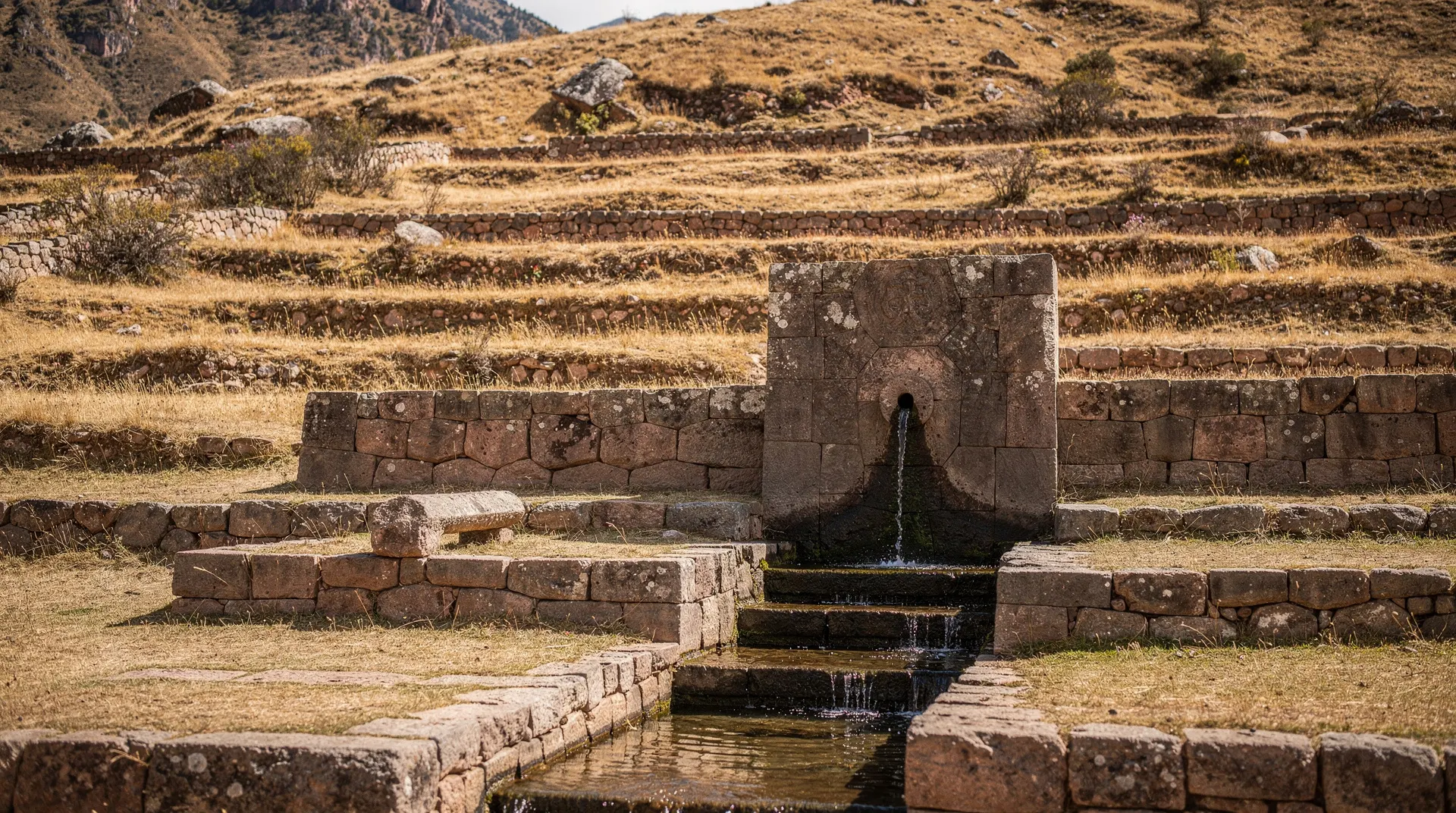
Tambomachay: the bath of the Inca
Tambomachay is the most elegant of the three sites and the most immediately appealing to visitors who are not archaeology specialists. It is a hydraulic complex — a series of Inca-built channels, fountains and niched walls constructed around natural springs. Water still flows through the channels today, in the same patterns it followed five hundred years ago.
The hydraulic engineering is precise: channels are cut to exact gradients that maintain flow without erosion, and the water is distributed through a sequence of fountains at different levels. The site is thought to have functioned as a ritual bathing place, possibly reserved for the Inca ruler or for ceremonial use during specific festivals. The Quechua name translates roughly as “resting place of the army,” though the bathing and fountain function is what the physical evidence supports most clearly.
The niched walls beside the channels are in very good condition — dressed stone, trapezoidal niches, no mortar. The setting is green, the sound of moving water is constant, and the site is rarely crowded even in peak season. Allow 30 to 45 minutes here.
Q’enqo: the carved rock labyrinth
Q’enqo is the strangest of the three sites and the one most visitors underestimate. From the road it appears to be a modest limestone outcrop with some carvings. Walking in, it becomes clear that the entire rock mass has been worked by Inca stonemasons into an elaborate sacred space: zigzagging channels carved to direct water or blood (the debate continues among specialists), a subterranean chamber accessible through a narrow passage, carved niches and flat surfaces that served as altars, and a natural fissure that splits the rock in two and may have held astronomical significance.
The name Q’enqo means “zigzag” in Quechua, a reference to the carved channels on the upper surface of the rock. Animal sacrifices conducted at the site would have sent blood or chicha flowing in specific directions through these channels; which direction the liquid took was read as an omen. The subterranean chamber — accessed by ducking through a low entrance in the rock — contains a flat stone surface that may have been used for mummification rites. The dead (and particularly the Inca royal mummies) occupied a significant role in ongoing Inca religious life, and there is a reasonable scholarly consensus that Q’enqo was a huaca (sacred place) associated with ancestor veneration and death ritual.
Walk through the site slowly rather than photographing quickly from the road. The details — the carved puma head on the upper rock surface, the carefully angled channels, the deliberate shaping of the rock’s natural features into functional spaces — reward close attention. A guide adds considerable value here; what looks like weathering to an untrained eye is often intentional carving.
Puca Pucará: the red fortress
Puca Pucará (red fortress, named for the reddish granite of its construction) is a compact administrative complex rather than a military fortification in any conventional sense, despite its name. It sits on a promontory commanding views of the valley and the road that was the ancient Inca highway north out of Cusco. The site includes storage rooms, plazas, baths and ceremonial areas arranged over several levels.
The most plausible interpretation is that Puca Pucará served as a tambo — a waystation and administrative checkpoint on the royal road network. Tambos were positioned at regular intervals across the empire, providing accommodation, storage, and administrative control over movement along the roads. This one, positioned just before Tambomachay and directly on the main approach to Cusco from the north, would have monitored and recorded traffic entering the capital.
Puca Pucará is the least dramatically impressive of the three sites but the most useful for understanding how the Inca governed at a practical level. The terraced walls are in reasonable condition; the views from the upper level are good. Allow 20 to 30 minutes.
How to visit: guided tour versus independent
The standard approach for visiting all four outlying ruins — Sacsayhuamán, Q’enqo, Puca Pucará and Tambomachay — is a half-day guided tour from Cusco that includes transport between sites. The vehicle connection between Q’enqo, Puca Pucará and Tambomachay matters because the sites are spaced 2–4 km apart along the road and are not easily walkable between them given the altitude and the absence of pedestrian paths.
A half-day guided city tour covering the ruins circuit is the most practical option and remains comfortably the most popular way to visit. A guide adds particular value at Q’enqo, where the significance of the carved features is not self-evident, and at Tambomachay, where the hydraulic function requires explanation to be fully appreciated.
For visitors who want to focus more specifically on the Cusco city sites alongside a general ruins overview, a city tour centred on Qorikancha sometimes incorporates the outlying ruins on a longer full-day version — check the itinerary details when booking.
Independent visits by taxi are also feasible: a driver who waits between sites across a half-day will typically charge S/60–90 total, which combined with the Boleto Turístico works out comparably to a mid-range guided tour for two people. The trade-off is the absence of interpretation.
Combining with Sacsayhuamán
Most visitors tackle all four sites together, and the logical sequence is: Sacsayhuamán first (closest to Cusco, largest, best in morning light), then Q’enqo, Puca Pucará and Tambomachay in that order along the road, finishing at Tambomachay and returning to Cusco from there. The entire circuit takes 3 to 4 hours including transport between sites.
Read the Sacsayhuamán page and the Boleto Turístico guide before your visit to understand what ticket covers which sites and whether the full circuit ticket makes financial sense for your itinerary. If you plan to also visit sites in the Sacred Valley, the full Boleto Turístico at S/130 is almost certainly worth the cost; if you are only doing the Cusco city circuit, you can do the maths on partial tickets.
The 4-day Cusco and Machu Picchu itinerary positions the ruins circuit on day three, leaving day two for the historic centre and Qorikancha. This sequencing is deliberate: the city sites provide narrative context for the outlying ruins, and the outlying ruins are more comprehensible after a day’s acclimatisation and background reading.
Practical notes
The road running past Q’enqo, Puca Pucará and Tambomachay is the main road to Pisac in the Sacred Valley. Collectivos (shared minibuses) from the Avenida Tullumayo terminal in Cusco run this route for approximately S/3–5 per person and stop on request near each site — a genuinely inexpensive alternative for independent travellers who do not need door-to-door service. Confirm the drop-off point with the driver before you board.
All three sites have minimal facilities. There are no cafés at Q’enqo or Puca Pucará; Tambomachay has occasional vendors selling water and snacks near the entrance. Bring your own water and a snack, apply sunscreen, and wear layers — at 3,700 m the midday sun is fierce but the wind at exposed positions drops the temperature quickly.
The Inca Empire guide for travellers provides the best available overview of Inca cosmology, water ritual, road networks and imperial administration — the four themes that connect Tambomachay, Q’enqo and Puca Pucará into a coherent story rather than three separate piles of stone.
The three sites at a glance
| Site | What it is | Time needed | Why visit |
|---|---|---|---|
| Tambomachay | Ritual bathing complex, working water channels | 30–45 min | Most visually elegant, least crowded |
| Q’enqo | Carved rock labyrinth, ritual chamber | 20–30 min | Strangest and most rewarding with a guide |
| Puca Pucará | Waystation and administrative checkpoint | 20–30 min | Best for understanding Inca road governance |
Frequently asked questions about Tambomachay, Q’enqo and Puca Pucará
Can I skip Sacsayhuamán and just visit these three sites? You can, and it saves time, but most guided half-day tours include all four together at similar cost, so there’s rarely a practical reason to skip Sacsayhuamán specifically — it’s the most visually dramatic of the four and worth the extra hour.
Which of the three sites should I prioritise if I’m short on time? Tambomachay for its elegant, still-functioning water engineering, and Q’enqo if you have a guide who can explain the ritual carvings — Puca Pucará is the most skippable of the three if time is genuinely tight.
Top experiences
Bookable activities with verified prices and instant confirmation on GetYourGuide.
