Palccoyo: the easier rainbow mountain alternative
Cusco: Full-Day Palccoyo Rainbow Mountain All-Inclusive Tour
The easier Palccoyo alternative
Palccoyo sits at 4,900 m (vs Vinicunca's 5,200 m) and involves a gentle 3 km circuit from the vehicle drop-off, compared to Vinicunca's 7 km with 900 m altitude gain. Day trips cost roughly $20–35 (S/75–130). You see three separate coloured ridges in one panoramic view with a fraction of the crowds. Still needs 2+ nights acclimatisation in Cusco — altitude is not mild here.
The rainbow mountain most operators don’t mention
Palccoyo exists about 65 km east of Cusco in the Vilcanota mountain range, and most visitors to the region have never heard of it. The operators who run most of the Rainbow Mountain tourism in Cusco primarily sell Vinicunca — it is the famous one, it commands higher prices, and it has the recognisable photograph. Palccoyo is the alternative they mention when someone specifically asks about a less demanding option.
This guide covers what Palccoyo actually is, who it suits, and what you will find there. The honest summary is that for a significant proportion of visitors to Cusco, Palccoyo is the better choice: lower altitude, shorter walk, fewer crowds, lower cost, and a panoramic three-ridge view that is genuinely different from and arguably richer than the single concentrated face of Vinicunca. The comparison is made in detail in the Vinicunca vs Palccoyo guide. This guide focuses on Palccoyo specifically.
| Where | Palccoyo plateau, Vilcanota range, ~65 km east of Cusco |
| Cost | $20–35 (S/75–130) per person including transport and guide |
| Time needed | Full day: ~3–3.5 hours’ drive each way plus a 2–2.5 hour circuit |
| Getting there | Organised tour essential — no practical independent access |
| Best time | May–September; January–February are the weakest weather months |
What Palccoyo is
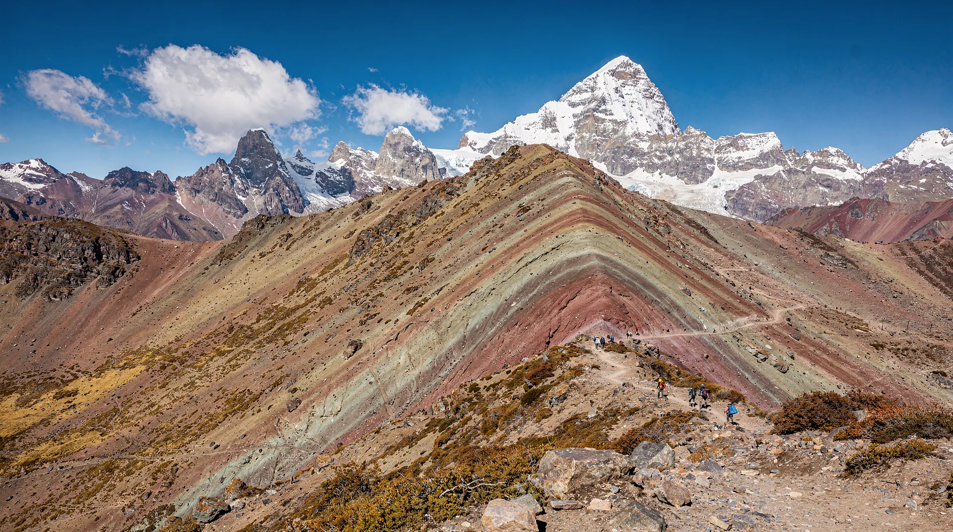
Palccoyo is a high-altitude plateau at approximately 4,600–4,900 m, on the flanks of the Vilcanota range in the direction of Ausangate from Cusco. Three separate ridges of the plateau show the same mineral colouring as Vinicunca — iron oxide reds and oranges, sulphur yellows, chlorite greens, clay purples — visible simultaneously from a single high viewpoint. Where Vinicunca gives you one concentrated face from below, Palccoyo gives you three ridges in a panoramic sweep from approximately level ground.
The geological explanation for the colours is identical to Vinicunca: the Andes have been subjected to enormous geological uplift over millions of years, and the different mineral layers deposited at different periods have been exposed by erosion into the characteristic stripes. At Palccoyo, the mineral exposure covers a wider area but is somewhat less concentrated at any single point — the visual effect is broader and more panoramic rather than the focused drama of Vinicunca’s single face.
The circuit in detail
Most Palccoyo tours follow a roughly circular route from the vehicle drop-off:
Vehicle drop-off (4,600 m): You arrive here after approximately 3–3.5 hours of driving from Cusco. Basic toilet facilities are usually available. The altitude here is already significant — pause, drink water, and allow your body to adjust for 10–15 minutes before beginning to walk.
First viewing point (4,700 m, ~45 min walk): The path from the drop-off climbs gradually across the plateau. Within 45 minutes to an hour you reach the first coloured ridge viewpoint, where two of the three Palccoyo rainbow mountains are visible. This is the point where most physically cautious visitors choose to stop if the altitude is affecting them significantly.
High point (4,900 m, ~1 hour from drop-off): The full circuit continues to the highest point on the route, which offers the complete panoramic view of all three coloured ridges and, on clear days, the Ausangate massif (6,384 m) behind them. This is the premium viewpoint and the one worth reaching if you are managing the altitude comfortably.
Return circuit (~1 hour back): The route back typically takes a slightly different path across the plateau, passing through wetland sections where you may encounter alpacas and, if the season and conditions are right, Andean birds including flamingos in the distance. The circuit returns to the vehicle drop-off in about 1 hour from the high point.
Total circuit: About 3 km, 2–2.5 hours at a comfortable altitude-appropriate pace. Most Palccoyo full-day tours allow 2.5–3 hours on site, giving you enough time to complete the circuit without rushing.
The colours at Palccoyo
The three Palccoyo ridges each have slightly different mineral compositions and therefore slightly different colour signatures:
The primary ridge (most visited) shows the most concentrated red-orange-yellow sequence, driven by iron oxide and iron sulphide minerals in the exposed rock face. The secondary ridge shows a cooler range — purples, greens, and greys — from chlorite and clay minerals. The third ridge is smaller and shows a mix of the two.
The colours at Palccoyo photograph with somewhat less editing than Vinicunca — the natural tones are vivid enough in good light that heavy saturation boosting is less common in genuinely honest Palccoyo photographs. The most common amateur photography mistake here is shooting in flat midday light rather than in the warm morning light that brings out the mineral tones.
Best photography conditions: Morning, May–September dry season, with low-angle light that enhances the contrast between the ridge mineral layers. In cloud, the colours are muted. In direct morning sun, they are at their best.
Altitude and acclimatisation
At 4,600–4,900 m, Palccoyo is genuinely high altitude. The “easier” comparison with Vinicunca is accurate in terms of physical effort — but the altitude is not mild, and treating this as a casual stroll is how visitors end up spending the circuit in a state of nausea and headache.
The minimum acclimatisation recommendation is 2 nights in Cusco (3,400 m) before attempting Palccoyo. Three nights is more comfortable. If you have been sleeping in the Sacred Valley at 2,800 m rather than Cusco, add at least 2 nights at Cusco altitude before attempting 4,900 m.
Symptoms to watch for on the circuit: persistent headache that worsens with altitude gain, nausea, dizziness on standing, confusion, or loss of coordination. Any of these beyond mild headache should prompt a slow descent back toward the vehicles rather than continuing. The altitude sickness guide covers the full symptom spectrum and the decisions to make at each level of severity.
Practical altitude preparations:
- Drink at least 2 litres of water the day before and the morning of the trip
- Move slowly — the circuit is not a race, and the altitude will govern your pace regardless
- Eat a light breakfast; a heavy meal before a high-altitude activity tends to worsen nausea
- Bring warm layers — the plateau is exposed and temperature at 4,900 m can be significantly colder than Cusco even on a sunny day
Who Palccoyo suits best
Based on the practical differences between Palccoyo and Vinicunca, Palccoyo is the right choice for:
Visitors with altitude concerns. If you have experienced significant altitude symptoms in Cusco, the 300 m difference between Palccoyo and Vinicunca is meaningful. More significantly, the shorter physical effort at Palccoyo means you accumulate less physiological stress during the circuit itself.
Families with older children or teenagers. The shorter circuit and lower altitude gain make the physical challenge more manageable. Children under 10 should be assessed carefully regardless.
Travellers over 50 or with any cardiovascular consideration. The combination of lower altitude ceiling and shorter exertion period at Palccoyo materially reduces the cardiovascular demand compared to Vinicunca.
Photography visitors who prefer panoramic landscape over concentrated drama. The three-ridge panorama with Ausangate behind it offers composition possibilities that the single-face Vinicunca viewpoint does not.
Anyone who dislikes crowds. Palccoyo in July — peak season — is noticeably quieter than Vinicunca in April. The difference in crowd density is large enough to affect the entire character of the experience.
Budget-conscious travellers. Palccoyo day trips typically cost $20–35 per person versus $30–50 for Vinicunca. The saving is modest but real.
Palccoyo versus Vinicunca at a glance
| Palccoyo | Vinicunca | |
|---|---|---|
| High point | 4,900 m | 5,200 m |
| Elevation gain on foot | ~300 m | ~900 m |
| Circuit distance | ~3 km | ~7 km return |
| Typical cost | $20–35 | $30–50 |
| Crowds in peak season | Low | High |
| The one thing it has that the other doesn’t | Petrified queñoa forest, three-ridge panorama | The iconic single striped-mountain photograph |
Getting to Palccoyo
From Cusco, the road to Palccoyo goes southeast via Urcos and then east toward Cusipata and Ocongate. The journey takes approximately 3–3.5 hours each way. The route passes through interesting high-altitude landscape including the Vilcanota valley; the last hour is on unpaved road that becomes rough in the wet season.
The only practical way to reach Palccoyo from Cusco as a day trip is on an organised tour — the logistics of public transport plus the trailhead location make independent access impractical for most visitors. A full-day Palccoyo tour typically includes pickup from Cusco hotels, transport both ways, a guide for the circuit, and the site entry fee (approximately S/10, included in most tour prices). Lunch is sometimes included; confirm before booking.
Palccoyo and Ausangate together
The Ausangate massif is the dominant peak in the background of the best Palccoyo viewpoints, and the two destinations are geographically in the same direction from Cusco. Some visitors who want a deeper experience of this part of the Andes combine a Palccoyo day trip with a separate Ausangate 7 lakes day trip — the two offer different scales and characters of the same mountain landscape.
The multi-day Ausangate trek is a separate category entirely: a 5–6 day circuit around the massif at 4,300–5,000 m, involving camping in very cold conditions and requiring proper trekking equipment and permits. It is one of the most rewarding multi-day hikes in Peru and the context that Palccoyo visitors can glimpse from the high point. If the Ausangate backdrop from Palccoyo triggers interest, the Ausangate trek guide covers what the full experience involves.
Practical information
Altitude: Vehicle drop-off ~4,600 m; high point ~4,900 m.
Walking distance: ~3 km circuit total.
Walking time: 2–2.5 hours at altitude-appropriate pace.
Day trip cost: $20–35 (S/75–130) per person including transport and guide.
Entry fee: Approximately S/10, usually included in tour price.
Drive time from Cusco: 3–3.5 hours each way.
Best season: May–September; January and February are the worst for weather.
Acclimatisation required: 2 nights minimum in Cusco (3+ recommended).
Comparing the Palccoyo experience to the online image
One under-discussed aspect of visiting any rainbow mountain site is the relationship between the photographs that drive visitor interest and what you actually encounter. For Palccoyo, this relationship is healthier than for Vinicunca.
Vinicunca photographs circulating online tend toward heavy post-processing — the saturation is routinely boosted to levels 40–60% above the natural scene. Photographers working the iconic viewpoint know that raw images often disappoint visitors who have seen the edited versions, and so the editing escalates to meet expectations that the editing itself created.
Palccoyo photographs are, on average, more honest. The natural tones of the three ridges — deep ochre and rust-red from iron oxides, patches of sulphur yellow, grey-purple from manganese minerals — are vivid enough in good morning light that less intervention is needed. The wider panoramic view also means that photographers tend to capture more landscape context rather than compressing everything to a single over-saturated face.
The result is that visitors to Palccoyo are somewhat less likely to arrive with inflated expectations and somewhat more likely to leave with photographs that look like what they actually saw. This is a modest benefit but a real one. The Vinicunca vs Palccoyo guide covers the photography comparison more fully for visitors where this is a deciding factor.
Community and conservation
Palccoyo sits within the jurisdiction of local Quechua-speaking communities who have managed access to the site and benefit from the entry fees. The conservation context is important: the plateau grasslands (puna) at this altitude are a fragile ecosystem, and the trail is managed to keep visitors on defined paths.
Local guides from the community are available at the drop-off point for an additional fee. Their knowledge of the plateau geography, the Ausangate massif above, and the cultural significance of specific landscape features to local communities adds a layer that organised tour guides from Cusco sometimes cannot provide. If you have a strong interest in the human geography of the high Andes as well as the landscape photography, a local guide is a worthwhile addition.
The income from Palccoyo tourism goes more directly to the local community than Vinicunca tourism, where the commercial infrastructure is more concentrated in Cusco-based operators. This is not a reason to choose Palccoyo on its own, but it is a consideration worth noting for travellers who care about where their tourism spending actually ends up.
What to confirm before booking
Because Palccoyo sits outside the standard tourist circuit that Vinicunca dominates, tour quality and inclusions vary more between operators. Before paying, confirm: whether the community entrance fee (~S/10) is included in the quoted price; whether lunch is packed or bought at a stop en route; the group size, since Palccoyo tours range from large shared minivans to smaller groups with more guide attention; and the exact pickup time, since both 4:00 am and 5:00 am departures exist. Read recent reviews specifically for punctuality and vehicle condition on the unpaved final stretch — this is the part of the day most likely to differ between operators, since the paved highway section is identical for everyone.
For groups of four or more, it is worth pricing a private vehicle against the standard shared tour: the per-person cost can come out similar once you account for the flexibility gained — a later or earlier pickup, more time at the high point, and the ability to stop at Checacupe or elsewhere en route without waiting on a group’s collective decision.
A realistic day-of timeline
4:00–5:00 am: Hotel pickup in Cusco. 5:00–8:30 am: Drive southeast via Urcos, Cusipata and Ocongate, with a breakfast stop en route. 8:30–9:00 am: Arrival at the vehicle drop-off (4,600 m); pause to adjust before walking. 9:00–11:00 am: The circuit to the high point and back, including the wetland return section where alpaca and occasional birdlife appear. 11:00 am–12:00 pm: Return walk and packed lunch near the vehicles. 12:00–4:00 pm or later: Return drive to Cusco. Build in a margin for traffic near the city on the return leg; do not plan anything demanding for the evening.